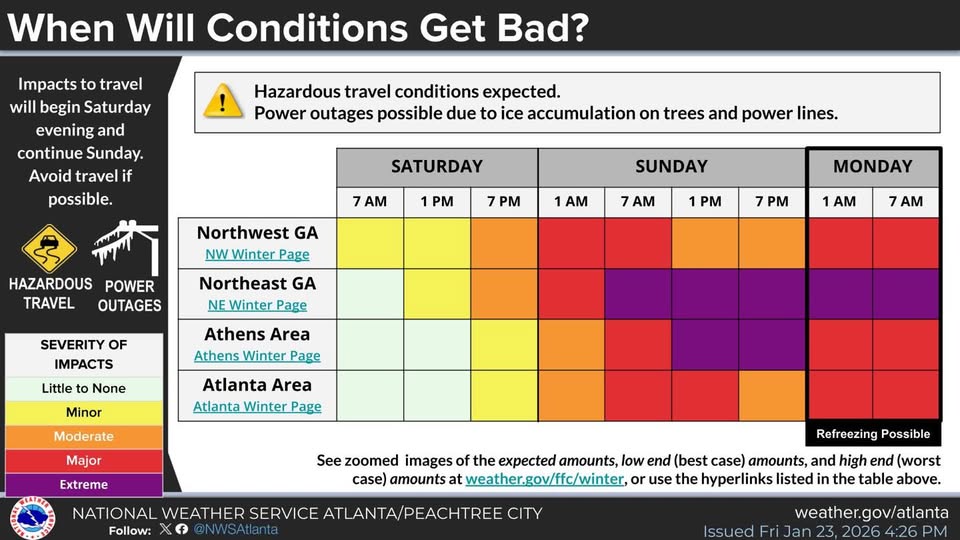
• Ice Storm Warning for Trenton - Click for Details
    ...ICE STORM WARNING REMAINS IN EFFECT UNTIL 10 AM EST MONDAY...
    Expires: January 26, 2026 @ 10:00am
    WHAT
    Significant icing expected. Total ice accumulations between a quarter and one inch are expected. Winds gusting as high as 35 mph.
    WHERE
    Catoosa, Chattooga, Dade, Walker, and Whitfield Counties.
    WHEN
    Until 10 AM EST Monday.
    IMPACTS
    Expect power outages and tree damage due to the ice. Travel could be impossible. The hazardous conditions will impact the Monday morning commute.
    PRECAUTIONARY/PREPAREDNESS ACTIONS
    Travel should be restricted to emergencies only. If you must travel, keep an extra flashlight, food and water in your vehicle in case of an emergency. Prepare for extended power outages. The latest road conditions for the state you are calling from can be obtained by calling 5 1 1.
  • Cold Weather Advisory for Trenton - Click for Details
    ...COLD WEATHER ADVISORY IN EFFECT FROM 4 AM TO 10 AM EST MONDAY...
    Expires: January 26, 2026 @ 10:00am
    WHAT
    Very cold wind chills from 15 above to 0 expected.
    WHERE
    Portions of central, east central, north central, northeast, northwest, and west central Georgia.
    WHEN
    From 4 AM to 10 AM EST Monday.
    IMPACTS
    Wind chills from 5 to 15 above across much of north and portions of Middle Georgia are expected with wind chills as cold as 0 in the north Georgia mountains. Avoid prolonged exposure if possible and have a safe heating source, particularly for those who may be experiencing power outages.
    PRECAUTIONARY/PREPAREDNESS ACTIONS
    Use caution while traveling outside. Wear appropriate clothing, a hat, and gloves. Make frequent checks on older family, friends, and neighbors. Ensure portable heaters are used correctly. Do not use generators or grills inside.

When Will Conditions Get Bad?

SHARE NOW

Information from the National Weather Service in Peachtree City.  Click the image below to view.